
Geography
Kharg Island’s location in the Persian Gulf has shaped its history, economy, and strategic importance for centuries. Although relatively small in size, the island’s geography and climate have made it one of the most significant energy hubs in the Middle East.
Kharg Island Infrastructure Map
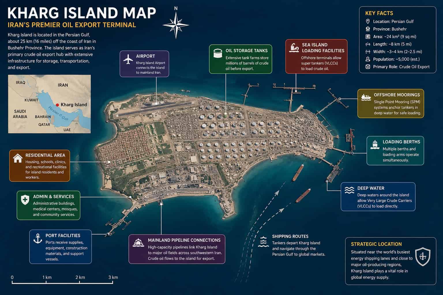
This detailed map highlights the major geographic and industrial features of Kharg Island, including its airport, residential areas, oil storage tank farms, port facilities, offshore loading terminals, deep-water berths, and mainland pipeline connections.
Kharg Island’s position in the northern Persian Gulf allows crude oil transported from southwestern Iran to be stored and loaded onto large international tankers. Its deep surrounding waters and extensive marine infrastructure have helped establish the island as Iran’s principal crude oil export hub.
The map also illustrates how closely the island’s transportation, residential, and industrial areas are connected within its relatively compact land area.
Overview
Kharg Island is situated in the northern Persian Gulf, approximately 25 kilometers (16 miles) off the coast of Iran in Bushehr Province. Measuring roughly 8 kilometers (5 miles) in length and between 3 and 4 kilometers (2 to 2.5 miles) in width, the island covers an area of about 24 square kilometers (9 square miles).
Its position places it near some of the world’s busiest maritime shipping lanes while providing access to deep-water channels capable of accommodating the largest crude oil tankers. These natural geographic advantages have played a major role in the island’s development as Iran’s primary oil export terminal.
Location
Kharg Island lies in the northeastern portion of the Persian Gulf, west of the Iranian mainland and southeast of Bushehr.
Geographic Coordinates
- Latitude: 29.26° N
- Longitude: 50.32° E
The island is part of Bushehr Province and serves as one of Iran’s most strategically important offshore locations.
Its proximity to mainland oil fields allows crude oil to be transported via pipelines directly to storage facilities and export terminals on the island before shipment to international markets.
Physical Geography
Unlike many tropical islands, Kharg Island is primarily composed of limestone and coral formations that have been uplifted over thousands of years. Much of the landscape consists of gently rolling terrain with rocky coastlines and relatively little natural vegetation.
The island features:
- Limestone plateaus
- Coral rock formations
- Low rolling hills
- Rocky shorelines
- Limited sandy beaches
- Sparse desert vegetation
Although much of the island has been developed for industrial use, portions of its natural geological landscape remain visible.
Coastline
Kharg Island’s coastline varies considerably around its perimeter.
The western and southern shores contain deeper waters that make them ideal for offshore loading terminals and oil export facilities. These naturally deep channels allow Very Large Crude Carriers (VLCCs) to safely load crude oil without extensive dredging.
Other sections of the coastline feature shallow reefs, rocky outcrops, and coral formations that support marine ecosystems native to the Persian Gulf.
Climate
Kharg Island experiences a hot desert climate (BWh) under the Köppen climate classification.
The island is characterized by:
- Long, extremely hot summers
- Mild winters
- Very low annual rainfall
- High humidity during much of the year
- Abundant sunshine
Summer temperatures frequently exceed 40°C (104°F), while heat indices can feel even higher because of humidity from the Persian Gulf.
Winter temperatures are considerably more comfortable, typically ranging between 15°C and 25°C (59°F to 77°F).
Rainfall
Rainfall on Kharg Island is limited and highly seasonal.
Most precipitation occurs during the winter months, with long periods of dry weather throughout the rest of the year.
Average annual rainfall is generally less than 250 millimeters (10 inches), making freshwater resources scarce. As a result, modern desalination plants provide much of the island’s potable water supply.
Wind & Weather
The Persian Gulf strongly influences local weather conditions.
Seasonal winds help moderate temperatures during parts of the year while also affecting marine operations.
Weather characteristics include:
- High summer humidity
- Occasional dust and sand events
- Strong seasonal northwesterly winds (known locally as the Shamal)
- Calm sea conditions during much of the year
- Rare but occasionally intense winter storms
Marine weather is carefully monitored because shipping operations continue throughout the year.
Natural Environment
Although industrial development dominates much of Kharg Island today, the surrounding marine environment supports a variety of wildlife.
Nearby waters contain:
- Coral communities
- Reef fish
- Sea turtles
- Dolphins
- Migratory seabirds
- Various shellfish species
The island itself supports hardy desert plants adapted to hot, dry conditions.
Environmental protection remains an ongoing consideration because of the close proximity of sensitive marine habitats to major petroleum infrastructure.
Why Geography Matters
Kharg Island’s geography is the primary reason it became Iran’s largest crude oil export terminal.
Several geographic advantages contribute to its importance:
- Close proximity to Iran’s largest oil-producing regions
- Naturally deep surrounding waters suitable for large tankers
- Strategic location within the Persian Gulf
- Direct access to international shipping routes
- Relatively short pipeline connections to mainland production fields
These characteristics have made the island one of the world’s most important energy transportation hubs.
Geographic Challenges
Operating major industrial infrastructure on a relatively small island presents unique challenges.
These include:
- Limited freshwater availability
- Extreme summer heat
- Corrosive salt-air environment
- Environmental protection requirements
- Limited land available for expansion
- Dependence on imported construction materials and supplies
Despite these challenges, continuous investment has allowed Kharg Island to remain one of the region’s most efficient export facilities.
Quick Facts
| Feature | Information |
|---|---|
| Country | Iran |
| Province | Bushehr |
| Body of Water | Persian Gulf |
| Approximate Area | 24 km² (9 sq mi) |
| Length | ~8 km (5 mi) |
| Width | 3 to 4 km (2 to 2.5 mi) |
| Climate | Hot Desert (BWh) |
| Average Summer Temperature | Over 40°C (104°F) |
| Average Winter Temperature | 15 to 25°C (59 to 77°F) |
| Annual Rainfall | Less than 250 mm (10 in) |
| Primary Economic Activity | Crude Oil Export |
Conclusion
Kharg Island’s geography has shaped every stage of its development, from its early role in Persian Gulf maritime trade to its modern position as Iran’s most important oil export terminal. Its deep-water access, strategic location, and proximity to mainland oil fields have made it an indispensable part of the global energy supply chain.
While harsh climatic conditions and limited natural resources present ongoing challenges, the island’s unique geographic advantages continue to support its critical role in international petroleum exports and regional commerce.
Related Pages
To learn more about Kharg Island, explore these related articles: