
KhargIsland.net uses publicly available research, government publications, historical records, satellite imagery, institutional databases, and reputable journalism to explain the history, geography, energy infrastructure, environment, and strategic importance of Kharg Island.
This page identifies the principal sources used throughout the website and explains how information is selected, evaluated, and updated.
Our Research Approach
Kharg Island is the subject of historical scholarship, energy analysis, government reporting, environmental research, and rapidly changing news coverage.
Whenever possible, KhargIsland.net gives preference to:
- Government agencies and official publications
- Academic and scholarly reference works
- Historical documents and archival records
- International research organizations
- Recognized environmental databases
- Satellite imagery from established space agencies
- Reputable news organizations with direct reporting
- Multiple independent sources for disputed or changing claims
No single source provides a complete account of the island. Information is compared across multiple sources when figures, dates, terminology, or interpretations differ.
Important Note About Changing Figures
Estimates involving oil exports, storage capacity, loading capacity, operating berths, tanker activity, and population may vary.
These differences can result from:
- Infrastructure upgrades or damage
- Temporary maintenance
- Sanctions and export restrictions
- Changing petroleum production
- Different reporting periods
- Satellite-based estimates
- Whether inactive facilities are counted
- Differences between designed and operational capacity
- Limited access to official Iranian information
When exact figures cannot be independently confirmed, this website uses qualifying language such as approximately, estimated, historically, or reported.
Readers should consider the date and methodology of a source before comparing it with another estimate.
Encyclopaedia Iranica
Encyclopaedia Iranica is one of the website’s primary sources for Kharg Island’s geography, archaeology, history, and modern development.
Its Kharg Island reference collection is divided into three detailed sections.
Geography
This entry covers the island’s location, dimensions, physical characteristics, climate, freshwater resources, traditional economy, population, and relationship with nearby Khargu Island.
History and Archaeology
Kharg Island II: History and Archaeology
This section examines archaeological remains, ancient tombs, religious sites, maritime trade, foreign occupation, and the island’s development before the modern petroleum industry.
Development Since the 1950s
Kharg Island III: Developments Since the 1950s
This entry documents the construction of pipelines, petroleum terminals, tanker facilities, industrial development, Iran-Iraq War attacks, postwar reconstruction, and Kharg’s role in Iranian oil exports.
Complete Kharg Island Collection
Encyclopaedia Iranica — Kharg Island
This parent entry links the complete three-part reference collection.
U.S. Energy Information Administration
The U.S. Energy Information Administration, commonly known as the EIA, publishes data and analysis concerning international petroleum production, exports, infrastructure, and maritime chokepoints.
Iran Energy Background
EIA — Iran Background Reference
This report provides information about Iran’s petroleum production, crude-oil blends, export terminals, pipelines, refining industry, and alternative export infrastructure.
It identifies Kharg as Iran’s largest oil-export terminal and discusses the main terminal, Sea Island facility, Iranian crude blends, and other export locations.
Iran Energy Overview
This resource contains broader information about Iran’s oil and natural-gas resources, production, consumption, exports, and infrastructure.
Strait of Hormuz
EIA — The Strait of Hormuz Is the World’s Most Important Oil Transit Chokepoint
This report explains the importance of the Strait of Hormuz, historical petroleum flows through the waterway, available bypass pipelines, and the relationship between Persian Gulf exports and international energy markets.
Historical and Declassified Documents
Historical intelligence reports provide contemporary assessments of Kharg Island during the Iran-Iraq War. These records are useful for understanding how governments viewed the terminal’s capacity, vulnerability, and economic importance at the time.
Declassified reports should be read as historical government assessments rather than unquestioned statements of fact.
Kharg Island Oil Terminal
CIA Reading Room — Kharg Island: Iran’s Principal Oil Export Terminal
This declassified report describes the terminal’s infrastructure, export role, vulnerabilities, tanker facilities, storage network, and strategic significance during the 1980s.
Oil Vulnerability During the Iran-Iraq War
CIA Reading Room — The Iran-Iraq War: Some Oil Vulnerability Issues
This assessment examines Iranian and Iraqi petroleum infrastructure, export limitations, potential disruptions, and Kharg’s position within Iran’s oil system.
U.S. Naval History and Heritage Command
The U.S. Naval History and Heritage Command provides historical material concerning the Tanker War, commercial shipping attacks, naval mines, Operation Earnest Will, and Operation Praying Mantis.
The Tanker War
Naval History and Heritage Command — Tanker War
This history explains the expansion of attacks on Persian Gulf shipping and the growing international involvement in protecting tanker traffic.
Operation Praying Mantis
Naval History and Heritage Command — Operation Praying Mantis
This publication covers the maritime conflict involving the United States and Iran during the final year of the Iran-Iraq War.
Government and Institutional Sources
U.S. Department of the Treasury
U.S. Treasury — Iranian Oil Terminals Company
The Treasury Department identifies the Iranian Oil Terminals Company as the organization overseeing Iran’s petroleum terminals, including the Kharg Island Oil Terminal.
Because Treasury publications may concern sanctions and foreign policy, they are used primarily for organizational information and official U.S. government positions.
Statistical Centre of Iran
Iranian census information is used when discussing the population of Kharg and surrounding administrative areas.
The most widely cited local figure currently comes from Iran’s 2016 National Population and Housing Census. Population figures should always include their census year because they may not represent the island’s present population.
Satellite Imagery and Maps
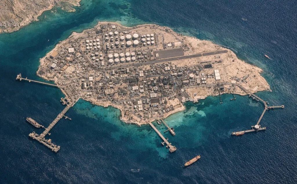
Satellite imagery helps readers understand Kharg’s geography, tanker terminals, storage tanks, offshore loading facilities, urban areas, and surrounding waters.
NASA Earth Observatory
NASA Earth Observatory — Kharg Island, Iran
This astronaut photograph and accompanying explanation identify major tanker docks, storage facilities, industrial infrastructure, and visible surface-water conditions.
NASA Earth From Space
NASA Johnson Space Center — Kharg Island
This resource provides an astronaut view of Kharg Island and information about its location and petroleum facilities.
Copernicus
The European Union’s Copernicus Earth-observation program provides Sentinel satellite imagery that can be used to examine land, coastal waters, infrastructure, and environmental changes.
Satellite imagery must be interpreted carefully. A visible feature may suggest a change or event without independently establishing its cause.
Google Maps
Google Maps is used on the Geography and Maps page to help visitors explore Kharg Island’s regional location interactively.
Map labels, boundaries, and place names may differ depending on language, provider, and regional settings.
Environmental and Wildlife Sources
Environmental information about Kharg and nearby Khargu Island is drawn from geographic research, conservation databases, satellite observations, and established environmental organizations.
BirdLife International
BirdLife DataZone — Kharku Wildlife Refuge
BirdLife International documents Khargu’s coastal environment, coral formations, vegetation, and importance to bird populations.
Key Biodiversity Areas
Key Biodiversity Areas — Kharku Wildlife Refuge
This database provides additional information about Khargu’s protected habitat and environmental characteristics.
Readers should note that Kharg and Khargu are separate islands. Information specifically concerning the Khargu Wildlife Refuge should not automatically be attributed to the more heavily developed island of Kharg.
Current News and Analysis
Current events involving Kharg Island can change rapidly. News coverage is evaluated using publication date, sourcing, direct reporting, supporting imagery, and confirmation from additional outlets.
Sources may include:
- Reuters
- Associated Press
- BBC
- Al Jazeera
- Council on Foreign Relations
- Major international newspapers
- Energy-industry publications
- Official government statements
- Maritime and tanker-tracking organizations
Council on Foreign Relations
Council on Foreign Relations — Kharg Island and Iran’s Oil Economy
This overview discusses Kharg’s economic importance, deepwater facilities, export role, and geopolitical significance.
Reuters
Reuters reporting is used for current tanker movements, sanctions, petroleum exports, infrastructure developments, satellite observations, and regional events.
Because news articles describe conditions at a particular moment, time-sensitive information should include a publication or update date.
Wikipedia and General Reference Sources
Wikipedia can provide a useful overview and help identify additional publications. However, it is not treated as the final authority for important historical, technical, environmental, or geopolitical claims.
Material initially found through a general reference source should be checked against its original citation whenever possible.
Images and Licensing
Images displayed on KhargIsland.net may come from:
- Public-domain government collections
- NASA imagery
- Wikimedia Commons
- Creative Commons collections
- Original graphics and maps
- Properly licensed news or stock photography
- Images used with permission
A source being publicly viewable does not automatically make its images free to reuse. Copyright status and license requirements should be reviewed before publication.
Where attribution is required, the image caption should identify the creator, source, and license.
Corrections and Updates
KhargIsland.net aims to distinguish documented facts from estimates, analysis, and disputed claims.
Pages may be revised when:
- More authoritative evidence becomes available
- Infrastructure or operating conditions change
- New census information is published
- A source corrects or retracts information
- Additional historical research clarifies an event
- A broken or outdated reference needs replacement
Readers should consider the publication date of an external source and the last-updated date of the KhargIsland.net page being viewed.
Editorial Independence
KhargIsland.net is an independent informational website.
It is not affiliated with:
- The government of Iran
- The National Iranian Oil Company
- The Iranian Oil Terminals Company
- Any military organization
- Any political party
- Any intelligence agency
- Any news organization cited on this website
Links are provided for research, attribution, and reader verification. Inclusion of a source does not imply endorsement of all its conclusions or policies.